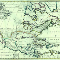
A new map of North America : shewing its principal divisions, chief cities, townes, rivers, mountains, &c.
Title
A new map of North America : shewing its principal divisions, chief cities, townes, rivers, mountains, &c.
Subject
North America -- Early works to 1800 -- Maps
Description
This map of North America by British cartographer Edward Wells depicts California as an island. This misrepresentation was based on accounts from the voyages of Hernando Cortes.
Creator
Wells, Edward (1667-1727)
Source
Publisher
Oxford : Printed at the Theater
Date
1701
Contributor
Burghers, M., engraver
Rights
Public domain
Format
maps (documents)
Language
English
Type
jpeg
Collection
Citation
Wells, Edward (1667-1727), “A new map of North America : shewing its principal divisions, chief cities, townes, rivers, mountains, &c.,” Digital Exhibits, accessed November 30, 2024, http://169457.591yf6gsz.asia/items/show/4654.
