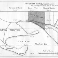
Shoalwater Reserve, Nisqually Agency, (1879)
Title
Shoalwater Reserve, Nisqually Agency, (1879)
Subject
Shoalwater Bay Indian Reservation (Wash.) -- Maps.
Description
1 map ; 12 x 18 cm.<br>From report text: Shoal Water Bay Reservation, containing about 340 acres and a population of 103 Indians, situated on the north shore of Shoal Water Bay of the Pacific Ocean, 90 miles southwest of Olympia, by the nearest traveled route.<br>Scale ca. 1:45,000.
Creator
United States. Bureau of Indian Affairs.<br>United States. Office of Indian Affairs. Puyallup Agency.
Source
University of Washington Libraries Government Publications Division.
Publisher
Washington, D.C. : Government Printing Office.
Date
1879
Contributor
University of Washington Libraries Map Collection
Rights
This image may be freely downloaded and used. Please give credit to the University of Washington Libraries.
Relation
In United States Congressional serial set, House Executive Document 1, part 5. Report of the Secretary of the Interior; being part of the message and documents communicated to the two houses of Congress at the beginning of the second session of the forty-sixth Congress. In three volumes. Volume 1. [after p. 254]
Format
image/jpeg
Language
English
Type
Maps
Identifier
uwm172<br>Y 1.1/2:serial 1910 map 2
Coverage
Washington (State) -- Pacific County -- Shoalwater Bay Indian Reservation
Collection
Citation
United States. Bureau of Indian Affairs.<br>United States. Office of Indian Affairs. Puyallup Agency., “Shoalwater Reserve, Nisqually Agency, (1879),” Digital Exhibits, accessed November 28, 2024, http://169457.591yf6gsz.asia/items/show/1491.
