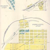
Plat maps of Belmont, Hay, and Pine City, (1910)<br>Plat book of Whitman County, Washington compiled and published from actual surveys and the County records by Anderson Map Company.
Title
Plat maps of Belmont, Hay, and Pine City, (1910)<br>Plat book of Whitman County, Washington compiled and published from actual surveys and the County records by Anderson Map Company.
Subject
Belmont (Wash.)--Maps<br>Hay (Wash.)--Maps<br>Pine City (Wash.)--Maps<br>Whitman County (Wash.) -- Maps<br>Anderson-Edwards Flour Mill<br>Texas Ferry Road<br>Dodson, Z.F.<br>Northern Pacific Railroad<br>Belmont, August <br>Burlington Northern Railroad
Description
1 map: col., 41 x 31 cm.<br>Plat maps from the Whitman County cities of Belmont, Hay, and Pine City, Washington. <br>Belmont scale 600'=1"<br> Hay scale 400'=1"<br>Pine City scale 400'=1"<br>A past director of the Northern Pacific Railroad, Mr. August Belmont, was given recognition when the town of Belmont, Washington was named after him in 1885. However, as with other Whitman County towns, other stories as to the name's origin have been suggested. Among these is the theory that Belmont means "beautiful mountain" and refers to the scenic view from there of Steptoe Butte. Another report said that there was a Belmont family that pioneered in the area. However it received its name, Belmont remained the NPRR rail terminus for only two years, when that distinction was pushed on to Lewiston, Idaho. Today it lies along the Burlington Northern line, and claims a few homes and a grain elevator.<br>Hay, Washington's naming stories run along similar lines: apparently the siding (flag stop for the Oregon Railway & Navigation Railroad) was stocked with an abundance of much needed Hay during the blizzard of 1893. It became known as "Hay Station" and later, just Hay. The town itself did not expand greatly until the 1920s and 1930s, when many of its buildings were constructed.<br>Pine City's beginnings was as a stage, not railroad station, of the Texas Ferry Road. The road ran from Walla Walla to Colville, and was originally an Indian road called "Texas Trail." Mr. Z.F. Dodson, an 1878 settler, platted the town in 1881. In just that first year, the town held a number of businesses, including a doctor's office, the Anderson-Edwards Four Mill, a number of general stores, a hotel, livery, blacksmith shop and a saloon. The Chicago Milwaukee and St. Paul Railroad came in 1905, and the mill was moved from its original site to make room for it.
Creator
Anderson Map Company.
Source
Manuscripts, Archives, and Special Collections, WSU Libraries
Publisher
Seattle, Wash. : Anderson Map Company
Date
1910
Contributor
Manuscripts, Archives, and Special Collections
Rights
Contact Manuscripts, Archives, and Special Collections, for copyright information 509 335-6691
Relation
Is part of Plat Book of Whitman County Washington Compiled and Published from actual Surveys and the County Records by Anderson Map Company Seattle, Wash 1910
Format
image/jpeg
Language
English
Type
Maps<br>Plats
Identifier
WSU 97
Coverage
United States--Washington (State)--Whitman County--Belmont
United States--Washington (State)--Whitman County--Hay
United States--Washington (State)--Whitman County--Belmont
Pine City
United States--Washington (State)--Whitman County--Hay
United States--Washington (State)--Whitman County--Belmont
Pine City
Collection
Citation
Anderson Map Company., “Plat maps of Belmont, Hay, and Pine City, (1910)<br>Plat book of Whitman County, Washington compiled and published from actual surveys and the County records by Anderson Map Company.,” Digital Exhibits, accessed November 28, 2024, http://169457.591yf6gsz.asia/items/show/1645.
