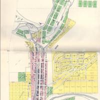
Plat map of Colfax (1910)<br>Plat book of Whitman County, Washington compiled and published from actual surveys and the County records by Anderson Map Company
Title
Plat map of Colfax (1910)<br>Plat book of Whitman County, Washington compiled and published from actual surveys and the County records by Anderson Map Company
Subject
Whitman County (Wash.) -- Maps<br>Colfax, Wash.--Maps<br>Belleville, Wash.<br>Colfax, Schuyler<br>Perkins, J.A.
Description
1 map: col., 69 x 36 cm.<br>Plat map from the Whitman County city of Colfax. Scale: 400'=1".<br>The farming town of Colfax (located thirteen miles northwest of Pullman) was named in 1872 in honor of President Grant's Vice President, Mr. Schuyler Colfax, by one of the town's earliest settlers--Mr. J.A. Perkins. (Perkins' first name for the area, Belleville, was in honor of his girlfriend at the time. He changed the name when they were no longer together.) Colfax incorporated in 1879 and began as a cattle raising and logging/lumber town. Many people believed the land was not suitable for farming. This all changed by the 1880s, however, with the first crop of winter wheat. As the county seat for Whitman County, Colfax resented being overlooked for the site of Washington State's new land-grant college. This honor was bestowed upon the town of Pullman in 1892.
Creator
Anderson Map Company
Source
Manuscripts, Archives, and Special Collections, WSU Libraries
Publisher
Seattle, Wash. : Anderson Map Company
Date
1910
Contributor
Manuscripts, Archives, and Special Collections
Rights
Contact Manuscripts, Archives, and Special Collections, for copyright information 509 335-6691
Relation
Plat Book of Whitman County Washington Compiled and Published from actual Surveys and the County Records by Anderson Map Company Seattle, Wash 1910
Format
image/jpeg
Language
English
Type
Maps<br>Plats
Identifier
WSU 146
Coverage
United States--Washington (State)--Whitman County--Colfax
Collection
Citation
Anderson Map Company, “Plat map of Colfax (1910)<br>Plat book of Whitman County, Washington compiled and published from actual surveys and the County records by Anderson Map Company,” Digital Exhibits, accessed November 30, 2024, http://169457.591yf6gsz.asia/items/show/1702.
