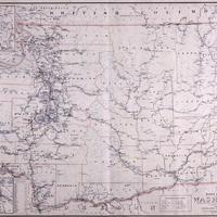
Post route map of the state of Washington : showing post offices with the intermediate distances on mail routes in operation on the 1st of September 1905 under the direction of A. von Haake, (1905)
Title
Post route map of the state of Washington : showing post offices with the intermediate distances on mail routes in operation on the 1st of September 1905 under the direction of A. von Haake, (1905)
Subject
Postal service -- Washington (State) -- Maps.<br>United States. Post Office Dept. -- Maps.<br>Washington (State) -- Maps.
Description
1 map : col. ; 77 x 106 cm.<br> Also shows frequency of delivery. Relief shown by spot heights. Seal of the Post Office Department, United States of America at head of title. Insets: Seattle and vicinity, Tacoma and vicinity<br> Includes list of counties showing relative position within state. Mounted on cloth backing. <P>The colored lines on the map show frequency of mail delivery as noted in the key at the bottom right of the map. Mail service could be as rare as just once a week in some areas.
Source
Manuscripts, Archives, and Special Collections, WSU Libraries
Publisher
[Washington, D.C.?] : Published by order of Postmaster General Geo. B. Cortelyou
Date
1905
Contributor
Manuscripts, Archives, and Special Collections
Rights
Contact Manuscripts, Archives, and Special Collections, for copyright information 509 335-6691
Format
image/jpeg
Language
English
Type
Maps
Identifier
WSU 369<br>G4281.P8 1905 .U5x
Coverage
United States--Washington (State)
Collection
Citation
“Post route map of the state of Washington : showing post offices with the intermediate distances on mail routes in operation on the 1st of September 1905 under the direction of A. von Haake, (1905),” Digital Exhibits, accessed November 28, 2024, http://169457.591yf6gsz.asia/items/show/1928.
